

- Published:
- Wednesday 10 April 2019 at 2:44 pm
- Location:
- , ,
- Published by:
- Department of Premier and Cabinet
The Victorian Aboriginal Heritage Council made decisions in April relating to the registered Aboriginal party applications from Eastern Maar Aboriginal Corporation and Boonwurrung Land and Sea Council (Aboriginal Corporation) formerly known as Yaluk-ut Weelam Elders Council Aboriginal Corporation.
The decisions are outlined below. The Victorian Aboriginal Heritage Council also received a notification from First People of the Millewa-Mallee Aboriginal Corporation of the withdrawal of its registered Aboriginal party application.
Date of decision: 4 April 2019
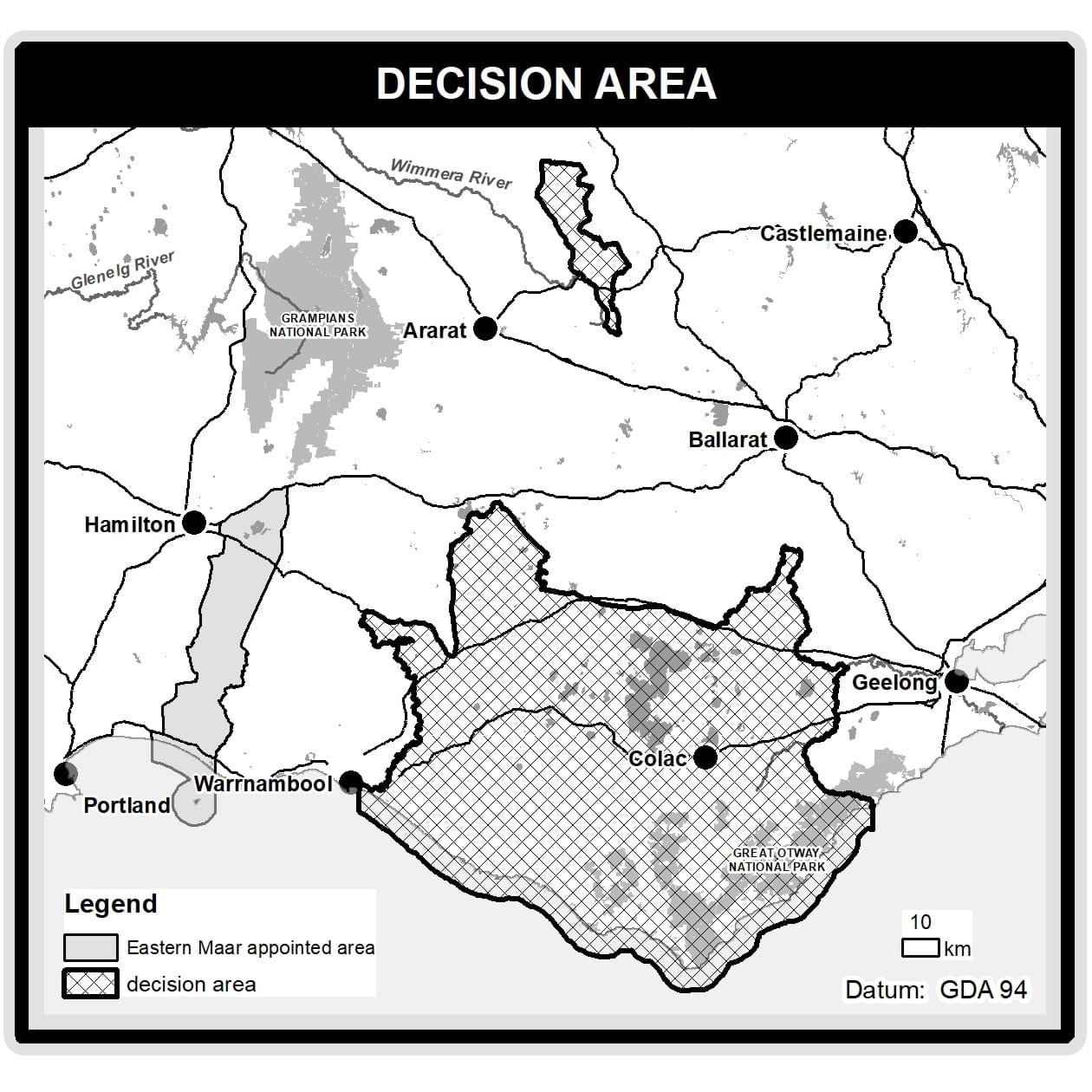
Decision to decline the Registered Aboriginal Party (RAP) application from Eastern Maar Aboriginal Corporation (EMAC)
At its meeting on 4 April 2019, the Victorian Aboriginal Heritage Council decided to decline EMAC’s RAP application in relation to:
i) the area east of Gariwerd which includes Navarre in the north, is bound by Dja Dja Wurrung Aboriginal Corporation’s RAP area to the east and Barengi Gadjin Land Council Aboriginal Corporation’s and Martang’s RAP areas to the west, and extends southerly to the boundary of Wathaurung Aboriginal Corporation’s RAP area; and
ii) the area located east of Warrnambool in the Western District of Victoria that has Camperdown and Colac at its center and which extends easterly to Winchelsea, northerly to Cressy, and southerly to the Victorian coast incorporating the great Otway National Park, Apollo Bay, Lorne and surrounding areas (Decision Area).
Both parts of the Decision are shown in the map below.
Council had asked EMAC to provide information about the traditional or cultural connection of Eastern Maar People to the Decision Area, and the experience of EMAC members in caring for Aboriginal Places in the Decision Area. Such information was not provided to Council.
While acknowledging EMAC’s claim to the Decision Area, Council had regard to claims by Kuuyang Maar Aboriginal Corporation and people identifying as Gulidjan Gadabanud to part of the Decision Area.
While Council acknowledged there may be members of EMAC who are Traditional Owners of the Decision Area, Council concluded, on the basis of information provided, that it could not be satisfied that EMAC is a body representing the Traditional Owners of the Decision Area.
Date of decision: 4 April 2019
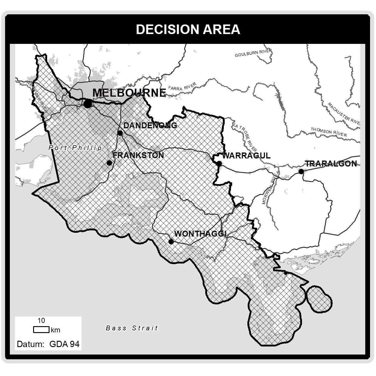
Decision to decline the Registered Aboriginal Party application from Boonwurrung Land and Sea Council Aboriginal Corporation (BSCAC) formerly known as Yaluk-ut Weelam Elders Council Aboriginal Corporation
At its meeting on 4 April 2019, the Victorian Aboriginal Heritage Council decided to decline the application from BLSCAC (formerly Yaluk-ut Weelam Elders Council Aboriginal Corporation) to become a RAP.
BLSCAC applied to the Council to become a RAP for an area that extends from the mouth of the Werribee River to and including Wilsons Promontory National Park (Decision Area). This area includes north western, western, eastern and south eastern Metropolitan Melbourne, Port Phillip Bay, Western Port Bay, and Cape Liptrap, and includes the area in respect of which Council appointed the Bunurong Land Council Aboriginal Corporation as RAP in July 2017. The Decision Area is shown in the map below.
In making its decision, Council had regard to information from the BLSCAC and requested additional material from the BLSCAC to support its application.
In making its decision, Council accepted that there are members of BLSCAC who are Yaluk-ut Weelam or Boon Wurrung Traditional Owners. However, Council was not satisfied that BLSCAC was the appropriate organisation to represent the Traditional Owners of the application area.
Date of acknowledgement: 4 April 2019
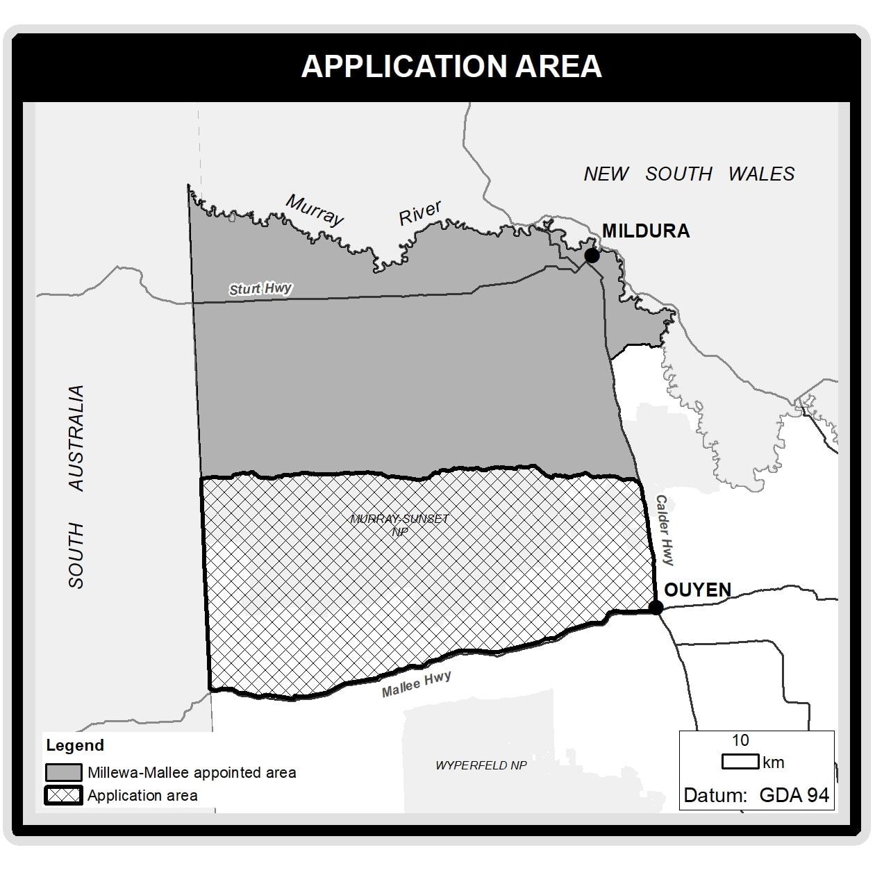
Notification from First People of the Millewa-Mallee Aboriginal Corporation (FPMMAC) of the withdrawal of its application to become a Registered Aboriginal Party
At its meeting on 4 April 2019, the Victorian Aboriginal Heritage Council acknowledged correspondence from FPMMAC notifying Council of the withdrawal of its RAP application in relation to the area Council deferred a decision on when FPMMAC was appointed as a RAP. The relevant area is shown in the map below.
Updated